
Low spot on the trail. When it rains, mud pit.
Desire paths Desire paths can be paths created as a consequence of erosion caused by human or animal foot-fall or traffic. The paths usually represent the shortest or most easily navigated routes between origins and destinations. https://en.wikipedia.org/wiki/Desire_path
Low spot on the trail. When it rains, mud pit.
Good point actually, that makes a lot of sense.
Or there was a barrier of sort there before, but now there isnt anymore.
Oh, that's a good notion. My thought had been that it's a place where people often stop so it formed a bypass of sorts.
Found the hiker.
Hmmm maybe, but the left is on a slope. The real path is lower, why wouldn't the rain pool there?
Here's a baseless guess: someone dumped something big on the trail there for awhile and a path formed from the detour and never went away
The real path is the one that floods. When it's wet, people use the desire path to avoid the puddle.
Ohhh!! Duh, I totally misinterpreted that haha. I am fully on board with your theory now
It's hard to tell from a picture, but to me, the road looks higher and everything slopes down to the right.
It is, but I misunderstood what the the person I replied to was saying (even though it was very obvious lol)
It's still possible that the main trail is lower in the middle than on its right edge witch would still cause a lot of mud with a good rain
The main path has a puddle there after rain. Source: British.
As another British person, that was the first thing I thought of when I saw the picture and I came here specially to make the same comment you did.
Australian here, same thought.
Uk too my thoughts were this is a regular horse riding route. Horses hate these paths and will move to the side making more
it looks like there could have been metal posts at these spots, maybe a fence to only let pedestrians through, and cyclists started going around
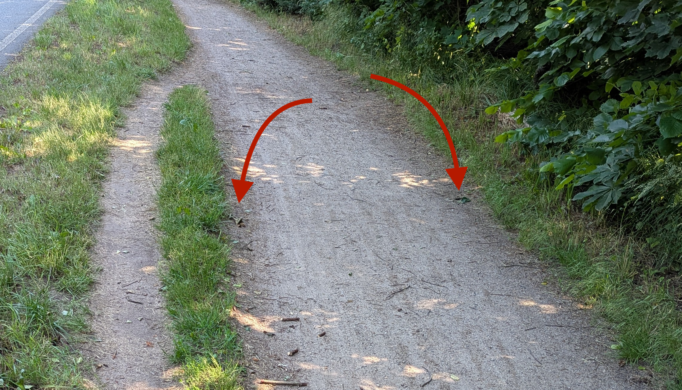
This was my hypothesis as well, but I didn't detect any position where a gate might have been. I'm quite sure the two spots you indicated are leaves.
if you know the original location, maybe check on street-view / satellite views. Google Earth also has the option to check older footage
I found the exact location for anyone interested: https://maps.app.goo.gl/RtuV3jA3MskYCgvE9
The desire path can be seen on streetview.

very cool! I looked in the city archives, there were building projects in 2011 and 2019 in that area, but there was no documentation about this particular spot, only that the way was too narrow and the surface material not adequate.
https://www.stadt-strausberg.de/wp-content/uploads/2018/01/NSZ-2011-09-Amtsblatt.pdf
wow! way to dig deep!
Those are just leaves. No local authority would leave twisted metal pole bases ready to slice people's heels. Surely...
good point! TÜV sagt nein.
Could have been tree overgrowth that has since been pruned.
Not once in my life have I seen a tree walk down a path like this
I do not think in the mud puddle theory. There is a moat right to the right where rain would drain. There is also no depression for holding any puddle.
I think there is a depression in the treeline and grass and also slightly on the road. I would say that there has been a broken/bend tree/bush laying in the way for over a year and was recently removed. There is no debre left, as the grass was also cut recently by a machine that also could have picked up any leaves.

The desire to overtake
...wait this isn't secretly a minelaying tips community is it?

Maybe shared pedestrian & bike trail? Bikes going around people
If this is in the US I would guess the city put a giant flashing "Share the Road" sign there for a while and everybody had to go around.
Looks like a bike track. Maybe that spot tends to be very muddy after rain, and therefore bikers drive around it?
It looks narrow down further so this would be a natural passing spot