this post was submitted on 25 Nov 2025
28 points (100.0% liked)

Climate

8496 readers
601 users here now

Discussion of climate, how it is changing, activism around that, the politics, and the energy systems change we need in order to stabilize things.

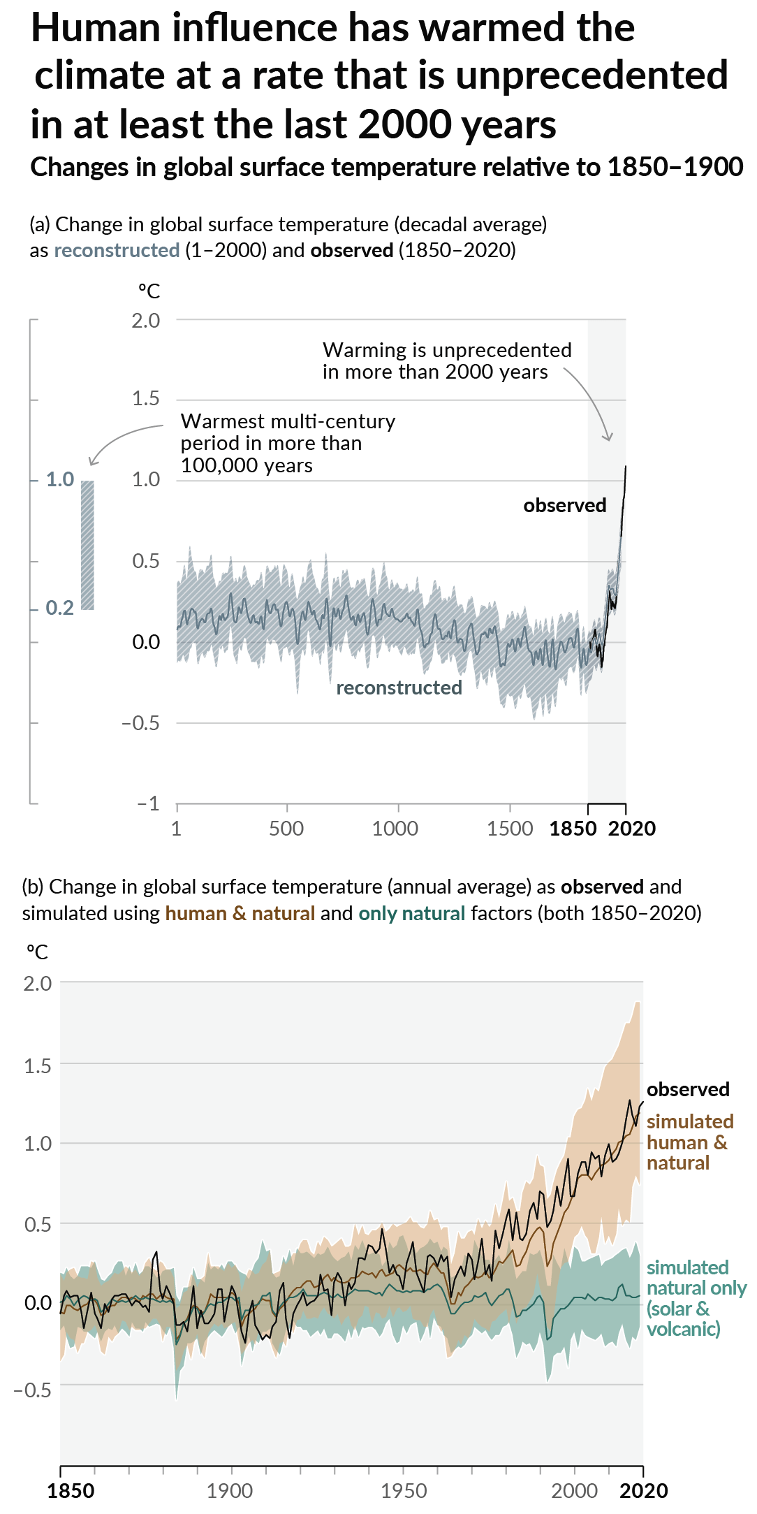
As a starting point, the burning of fossil fuels, and to a lesser extent deforestation and release of methane are responsible for the warming in recent decades: Graph of temperature as observed with significant warming, and simulated without added greenhouse gases and other anthropogentic changes, which shows no significant warming

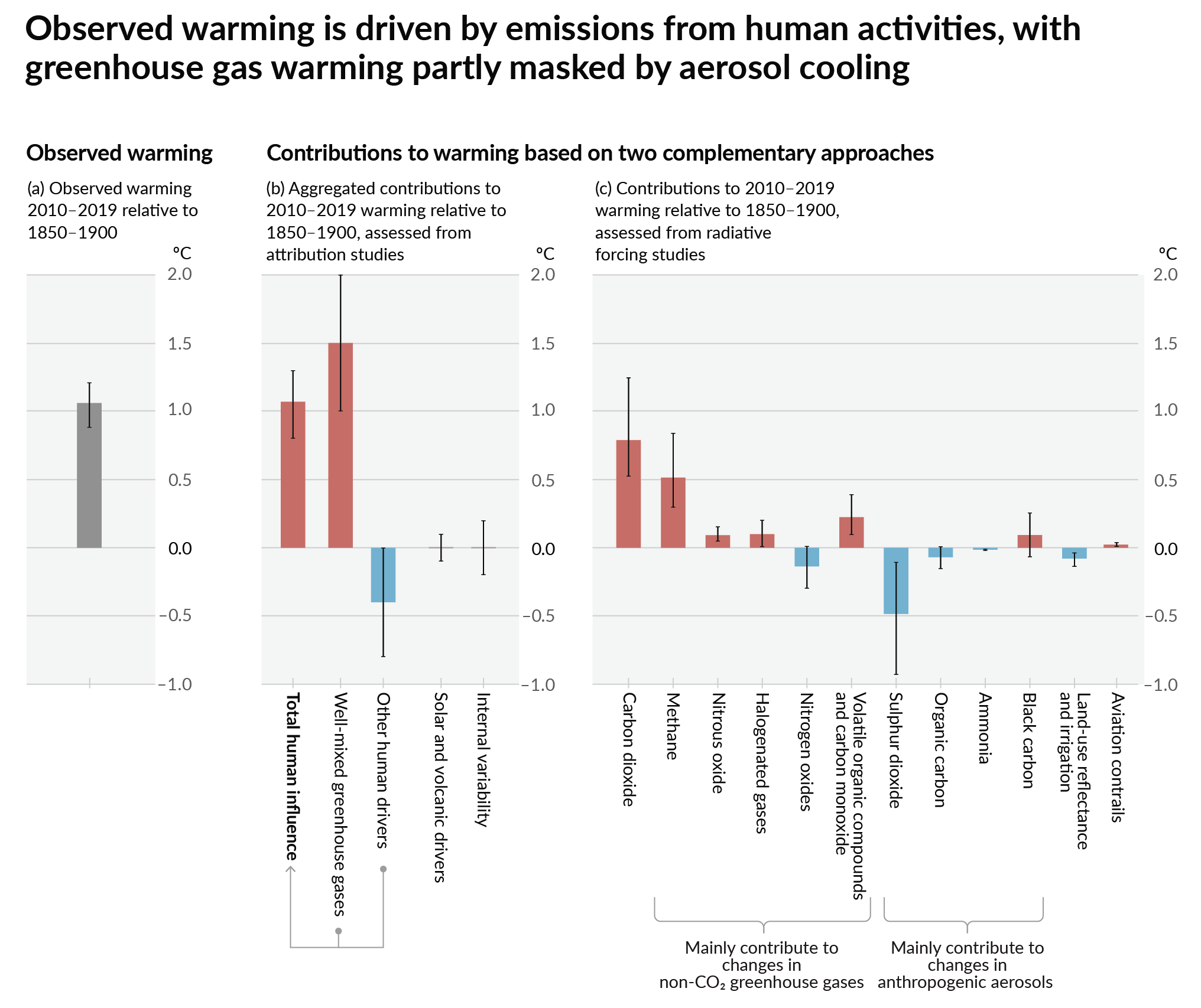
How much each change to the atmosphere has warmed the world: IPCC AR6 Figure 2 - Thee bar charts: first chart: how much each gas has warmed the world.  About 1C of total warming.  Second chart:  about 1.5C of total warming from well-mixed greenhouse gases, offset by 0.4C of cooling from aerosols and negligible influence from changes to solar output, volcanoes, and internal variability.  Third chart: about 1.25C of warming from CO2, 0.5C from methane, and a bunch more in small quantities from other gases.  About 0.5C of cooling with large error bars from SO2.

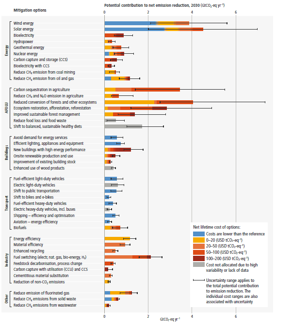
Recommended actions to cut greenhouse gas emissions in the near future:

Anti-science, inactivism, and unsupported conspiracy theories are not ok here.

founded 2 years ago
MODERATORS
 

Despite continuous efforts to evaluate and predict changes in Earth's climate, most models still struggle to accurately simulate extreme precipitation events. Models like the Coupled Model Intercomparison Project Phases 5 and 6 (CMIP5 and CMIP6) use fairly coarse resolution due to computing constraints, making it a little easier, faster and less expensive to run simulations, while still providing some degree of accuracy.

However, a new study, published in Nature Geoscience, is shedding light on some of the features missed by these coarser resolution models.

The team involved in the study developed a higher resolution model that breaks up the atmosphere into 10–25 km (6–15.5 mile) squares for analysis, instead of 100 km (62 mile) squares. Their high-resolution model is based on the Community Earth System Model v.1.3 (CESM-HR), which looks at the time period between 1920–2100. These results are then compared with the low-resolution version's (CESM-LR) results.

no comments (yet)
sorted by: hot top controversial new old
there doesn't seem to be anything here