26
31
submitted 2 months ago by jorge@feddit.cl to c/openstreetmap@lemmy.ml

StreetComplete is an easy to use editor of OpenStreetMap data available for Android. It can be used without any OpenStreetMap-specific knowledge. It asks simple questions, with answers directly used to edit and improve OpenStreetMap data. The app is aimed at users who do not know anything about OSM tagging schemes but still want to contribute to OpenStreetMap.

27
21
submitted 2 months ago by jorge@feddit.cl to c/openstreetmap@lemmy.ml
28
17
submitted 2 months ago by toaster@slrpnk.net to c/openstreetmap@lemmy.ml
29
24
submitted 2 months ago by infeeeee@lemm.ee to c/openstreetmap@lemmy.ml

To connect simply run:

telnet mapscii.me
30
188
31
22
submitted 2 months ago by Ludrol@szmer.info to c/openstreetmap@lemmy.ml

I wonder how many I have already mapped.

32
76

Pretty cool idea by using open street maps you can download the location you want and play the game there, defend your neighborhood or loot your house.

The reviews seem decent but mention it needs a lot of tweaking as it just released on early access, like water not affecting where zombies can walk or elevation not being a thing.

Maybe this can get some more people interested in mapping

33
55
submitted 2 months ago by Mex@feddit.uk to c/openstreetmap@lemmy.ml

2004: OpenStreetMap is founded because Ordnance Survey won’t make their data open

2024: Ordnance Survey now publishes its data in OpenStreetMap format because that’s what people expect

-- Richard Fairhurst @richardf

34
9
osm2gmaps (codeberg.org)
submitted 2 months ago by soloojos@lemmy.ml to c/openstreetmap@lemmy.ml

Convert your OpenStreetMap-based application links into Google Maps, Apple Maps or other links (and vice versa) without having to use proprietary software!

osm2gmaps converts links from applications like Organic Maps or OSMand to proprietary maps links, like Google Maps or Apple Maps. Just copy the link and share it to osm2gmaps or copy and paste it inside the app, it will automatically convert the link to your chosen type and copy it to the clipboard.

35
16
submitted 3 months ago by ray@lemmy.ml to c/openstreetmap@lemmy.ml
36
30
Unmapped USA - Mastodon Bot (self.openstreetmap)
submitted 3 months ago by governorkeagan to c/openstreetmap@lemmy.ml

I thought I’d share this Mastodon bot - @SmallTownUSA - here as I’ve found it great fun.

Posting towns in the USA with a population less than 1000 that are undermapped on OpenStreetMap.org

I quite enjoy mapping areas that have nothing or very little mapped. This bot kind of helps with that. Although, I’d love another one for my home country and current country of residence.

Bot’s GitHub

37
13
submitted 3 months ago by rando@lemmy.ml to c/openstreetmap@lemmy.ml

I would like to use openstreetmap as replacement for google maps (on web) However default nominatim doesn't generally give correct address (when searched for POI). Is there way to change nominatim provider?

38
48

Organic Maps is available on Linux! It's on flatpak and several package repos (but not apt). I don't know how long it's been there — I just discovered it.

The splash screen cautions that this Linux beta doesn't have parity with the mobile apps yet, but it's still a huge leap over Gnome Maps. Vector rendering, so you can zoom in as far as you want, and free / open source / not shitty (notwithstanding the big scary EULA, which just contains all the OSS licenses for all the pieces).

39
36

Where is it coming from? Are there other open sources of map data?

I've seen multiple mapping websites that provide business solutions that seemed to be sourcing their data from OSM. However, when I zoom in to known problem areas, I find a lot more detail. They're not getting it from Google, Bing, or Apple, and I find it implausible that these small specialized companies are sinking tens of thousands of hours into adding fine map detail. So where are they getting it? If it is open source is there a way to merge it back into OSM?

For example this website, maptiler, cites open street map as their source. Compare it with the official site. I have found multiple examples of the same thing. Can anyone explain to me what's going on here?

40
112

Crowdworked mapping: more fun in #OpenStreetMap! 🗺️ 🫶

Traveled back to my home court #UPLB to bring the great news of #opendata #foss4g to young leaders! Grateful for the opportunity 🙏🏼🙏🏼

thank you besh @dfeyeandal for coming with! New #youthmappers chapter, yeah? 😉✊🏼❤️‍🔥

@openstreetmap

41
80
42
17
submitted 4 months ago* (last edited 4 months ago) by gedaliyah@lemmy.world to c/openstreetmap@lemmy.ml

I live in an area where tons of data is missing. I mean the whole areas with no street addresses, missing streets, missing bike routes, etc.

Is there a guide or special tools for preparing to make massive edits like this? Is there a particular work flow that people use or resources? How do I even get started?

43
9
submitted 4 months ago* (last edited 4 months ago) by governorkeagan to c/openstreetmap@lemmy.ml

I asked on Mastodon but no one seems to know so I thought I’d ask here as well.

I’m looking for an app that provides the same or similar functionality to Life360 but instead of using Google/Apple map data it uses OpenStreetMap data. Does this even exist?

44
22

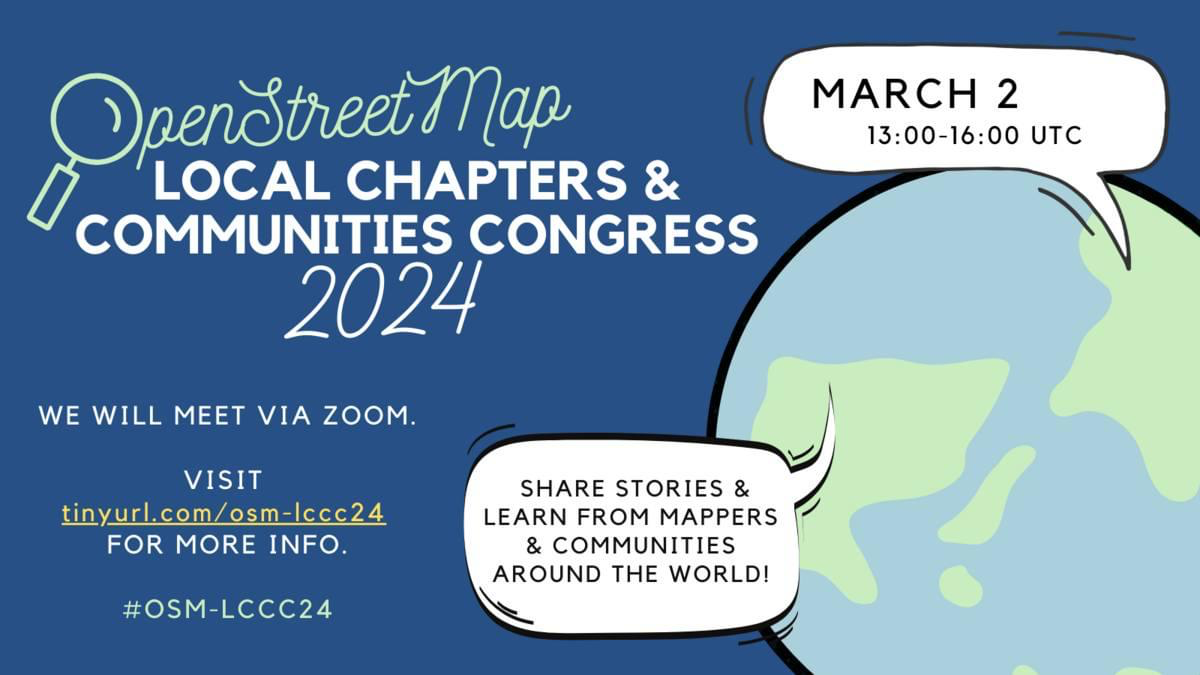
Join us this Saturday, 2 March for #OpenStreetMap Local Chapters and Communities Congress (LCCC) 2024!

Let’s get together and discuss efforts to support &grow our mapping communities!

Register now & spread the word! 🗣️ https://tinyurl.com/osm-lccc24 #osmlccc24

See you! @openstreetmap@lemmy.ml @openstreetmap

45
42
46
15
submitted 4 months ago* (last edited 4 months ago) by CowsLookLikeMaps@sh.itjust.works to c/openstreetmap@lemmy.ml

If you look at their Github account, there hasn't been a commit to their Android app in 3 years: https://github.com/kartaview/android

However, their Google Play listing shows it was last updated on February 8, 2024. https://play.google.com/store/apps/details?id=com.telenav.streetview

When Grab Holdings acquired KartaView, did they just take the open source code and start working on a proprietary copy? It's MIT licensed which allows commercial use.

47
16

Sorry, crooked isn't the best word, but I can't think of a better one.

I'm still quite new to OSM, and I want to start adding the buildings in my town. When I open the edit option though, the map overlay is at an angle. It's not a massive amount, but it's enough that you can see one sometimes two sides of most buildings, so the roof isn't aligned straight down, if that makes sense?

I live near Aberdare in South Wales, and you can see that where someone has added some buildings in the town centre at some point, they're now not aligned with the map overlay:

https://www.openstreetmap.org/edit#map=20/51.71312/-3.44499

Do I draw around the roof that I can see on the map? Do I edit the existing buildings so that they line up with the overlay? I'm not sure what the best course of action is for something like this.

Thanks in advance :)

48
13
submitted 4 months ago* (last edited 4 months ago) by infeeeee@lemm.ee to c/openstreetmap@lemmy.ml

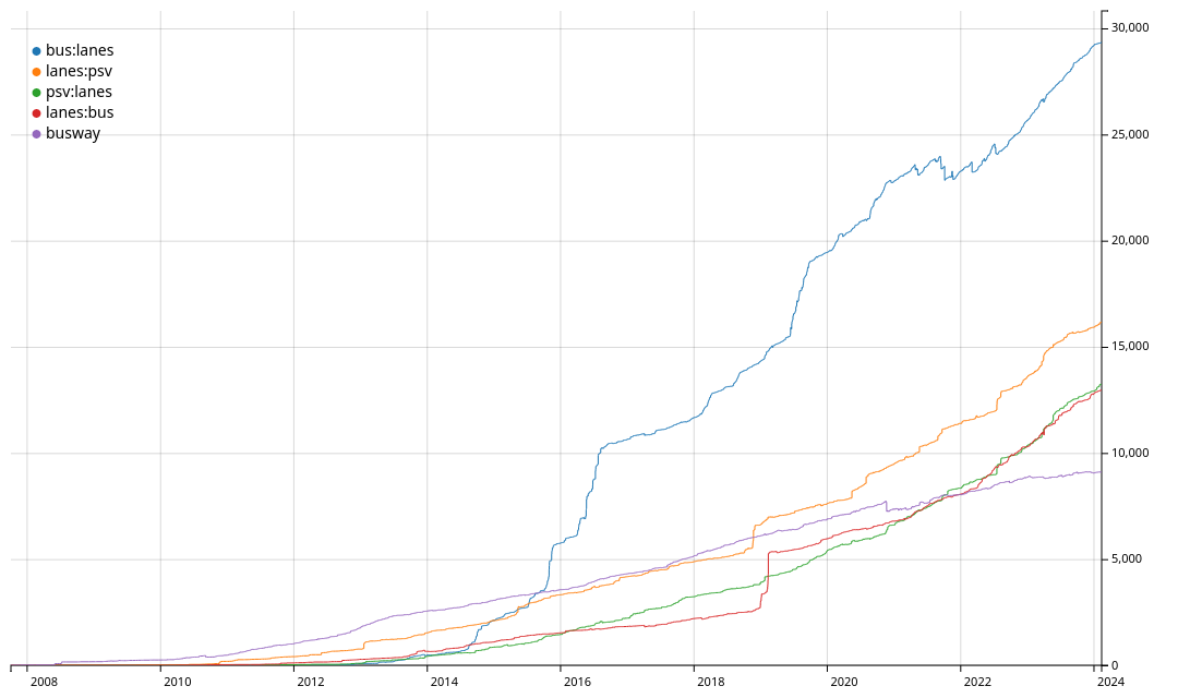
https://taghistory.raifer.tech/#/bus%3Alanes/&/lanes%3Apsv/&/psv%3Alanes/&/lanes%3Abus/&***/busway/

I use psv:lanes, but there are no real bus lanes here, it's called buslane, but law says taxis can also use it.

49
10
#shamelessplug 👀 (en.osm.town)
submitted 4 months ago* (last edited 4 months ago) by arnalielsewhere@en.osm.town to c/openstreetmap@lemmy.ml

#shamelessplug 👀

my prolonged #OpenStreetMap diary about my experience as an OSMF board member. Apologies for the delay!

🪑🗺️community in the map and at the table: my first year and continuing plans as OSMF board member

👉http://openstreetmap.org/user/arnalielsewhere/diary/403493

@openstreetmap

50
25

Hello all!

Is there some app like OsmAnd that lets you plan a route for an electric vehicle? I really love OsmAnd, but as far as I can tell, it lacks the ability to set a destination and plan a route based on the vehicle's range and the available charging stations. It would also be nice if you could specify whether you want to use fast chargers or not. Most highways do have fast chargers, but it would be bad if the route led to a non-fast charger for longer trips.

view more: ‹ prev next ›

OpenStreetMap community

3542 readers
2 users here now

Everything #OpenStreetMap related is welcome: software releases, showing of your work, questions about how to tag something, as long as it has to do with OpenStreetMap or OpenStreetMap-related software.

OpenStreetMap is a map of the world, created by people like you and free to use under an open license.

Join OpenStreetMap and start mapping: https://www.openstreetmap.org.

There are many communication channels about OSM, many organized around a certain country or region. Discover them on https://openstreetmap.community

https://mapcomplete.osm.be is an easy-to-use website to view, edit and add points (such as shops, restaurants and others)

https://learnosm.org/en/ has a lot of information for beginners too.

founded 4 years ago
MODERATORS