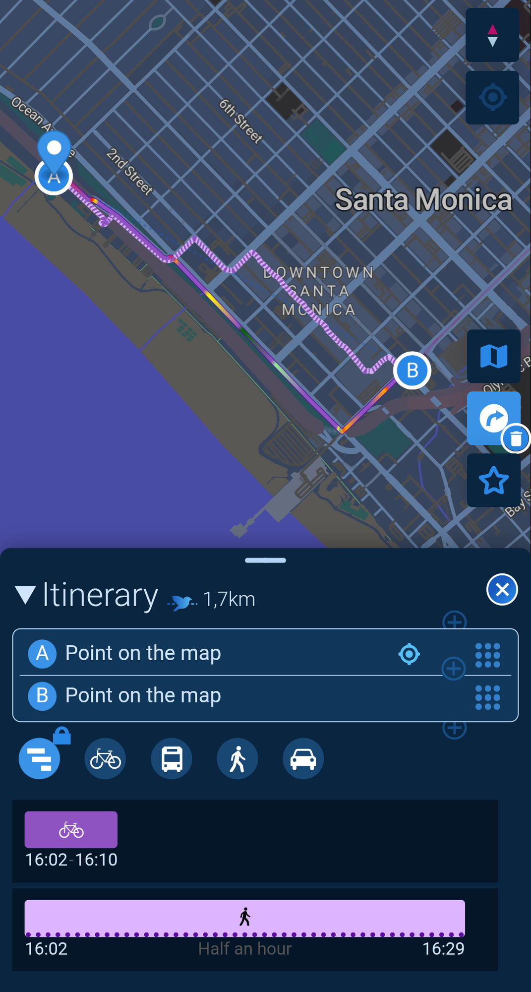
116
Google maps is drunk. I'm at the blue dot & wanted to see how long it would take to walk to the red flag and this is the route it suggested.
(lemmy.dbzer0.com)

Just post something 💛
Lemmy's general purpose discussion community with no specific topic.
Sitewide lemmy.world rules apply here.
Additionally, this is a no AI content community. We are here for human interaction, not AI slop! Posts or comments flagged as AI generated will be removed.
this is the route your body would take when youre ran over half way there
Yeah, my guts stuck to the bottom of his tires as he drives all around Southern California
I find many of the changes google has made in the last 2 years really stupid.
The "go past this light and turn at blah blah road" is way too fucking wordy and can lead to missing turns because by the time its dome speaking you have already drove past. I want road name plus minimal direction feature. Stop trying to humanize the gps. I think I yell at the GPS to shut the fuck up more and more.
Google is better than Siri. My wife is so iPhone and so anti-Android, but even she hates how Siri waits until the last second.
For real. Half the time I am like “You mean turn on the street I drove past two seconds ago?”
Time to check out Cartes.app! https://cartes.app/?clic=34.02076%7C-118.50899
It uses OSM and has some very useful routing options for foot/bike/public transportation.
Damn, you computer nerds are amazing. One of your coordinates is SPOT ON. 💯
Cartes.app is amazing.
It excels at route planning but then it encourages you to use comaps for the actual navigation. Because its offline.... its a beautiful opensource ecosystem
I can't tell from their site -- are they using a service like GraphHopper or Valhalla for routing, or have they rolled their own? If they're doing a limited amount of public transport routing, fuel efficiency calculations, etc, I guess it's the latter?
The project is open source: https://codeberg.org/cartes
They combine a bunch of different services and list them all out here (unless you speak french, you'll want to translate the page): https://cartes.app/verso
Looks like they're using Valhalla for routing as well as MOTIS/Transitious, Node-GTFS, GRAZE, and Transport.data.
Thanks! I was wondering whether I'd get any benefit from their routing versus GraphHopper's web UI; sounds like right now, that'll just be in parts of France.
That app told me to leave the main road and go on a dirt road

That looks like you have it set for cycling. It defaults to a "Safe" mode which would likely take you on alternate paths that are less travelled by cars. At the bottom you can change the route option to "Road" or "Balanced". If it still wants you to take a dirt road after selecting "Road", then it's a problem with OpenStreetMap.
You can fix those issues by going to openstreetmap.org then zoom in on the area and edit the map. Make sure that the main road exists all the way through and that the dirt road is tagged with highway=track.
Its a fun offroad adventure, scenic route for sure. Just go for it, all gas no brakes! (Watch out for golfers, flying golf balls, sand traps, golf carts, etc)
Should be noted that OpenStreetMap relies on volunteers to map their surroundings. So it can be quite inaccurate, depending on where you are
But that also tells you to help out and get mapping! It's surprisingly fun. And with apps like StreetComplete you can help out supplementing existing data in a very easy way
Once I was driving home on the highway and Google maps suggested I get off at the next exit. Sometimes there's heavy traffic at the entrance of my city so I figured it would make me save a few minutes by approaching from another angle.
Nope, it made me take the exit, drive a kilometer in a dead end then turn a roundabout, drive back and enter the highway exactly where I exited it.
A few fun things Google Maps has done recently:
Going to a friend's new house in a rural area with long, long driveways. Google maps told us to go up their neighbor's driveway, park at their neighbor's house, and walk 1500 feet across a canyon.
Getting to a train station in Philadelphia, you know the kind of place that's had a steady address for probably at least a century: Sent me to a MicroCenter (I think it was) about a mile away. Finally figured out it was because there was a hotel behind it, and a lot of the reviews mentioned convenient access to the train station.
Google audio directions are also garbage if you're relying on audio (like riding a motorcycle). Often doesn't repeat the street name when you have to turn, which is fun when there are two or three streets in close succession. Also seems to pick a random distance from your turn to tell you to turn. Sometimes it's several hundred feet before, sometimes it's only just as you're passing the turn.
It sent me in circles last week. I didn't know the area and thought the road was maybe under construction. Nope, it wanted me to be late.
There's a really old Top Gear episode, where someone sent in a suggested travel route (they did verify it) from one of the online services. What they wanted was "go from this one part of London to this other part of London, but avoid the big motorways". The suggested route had the submitter leaving London and crossing the Channel into France ...
I've found that Gmaps has gotten so bad, that I instinctively go to CoMaps these days,
Google has really gone down the shitter so far as to be near useless sometimes.
I can’t remember what I tried to search for a few days ago, but I used “quotes” to restrict the search (not that modifiers mean shit anymore, they’re often completely ignored) and got zero search results.
Zero.
It wasn’t even that restrictive of a search term. Nowhere on the entire english speaking internet has someone not written what I asked for? Literally impossible. Want to know how bad it was? It couldn’t even be bothered to give shitty AI results.
15 years ago there would have been several pages of results. But now, nothing. Probably because my request couldn’t be monetized.
In Delft, in the Netherlands, there is a rest stop at the motorway, and next to it is a monument to Delft porcelain. You can't reach it from the rest stop, though, as it is on the other side of a canal, but there are roads next to it on that other side, so I asked Google Earth how to get there.
But instead of what I expected (like use the next exit and follow that road to the monument), it simply suggested I walk across the canal...
......well, did you?
Am I Jesus?
Are you?
I don't know your real name, so for all I know, you could be
Am I close?

You are VERY close 😃
I mean your route walks nearby where I used to live so you can stalk me too if you want
Okay but if you USED to live there that means you're not currently there, so... 🤷🏼♀️
That's the mystery detective 🔍 True stalkers will use this to actually find me. I've left 5 paper notes in the surrounding area with clues about my current whereabouts! Collect all 5 and when you solve the puzzle-
Yeah, I thought that was you.
Don't worry, my freezer is full. A couple of weeks, at least.
Now thats a course with some chest hair!
Not enough comets or black holes.
There's a spot on Main Street in my town, a road with two sidewalks, where it forces me to cross the street for no reason. Like, there's just a dead spot on Google maps right there, it makes no sense.
Do you have a midpoint set at the grey dot with a (1) ?
I have entered no such settings. Anyway I clicked start and it sorted itself out. It told me it's a straight route, a 37 minute walk.
Okay now for the bonus challenge since I've told you all my location, come find me while I'm out walking LOL
Bit far from me: 
I'll catch the next ice age to walk across the atlantic then, hope I won't be late
You selected walking, which relies on it having accurate data on public spaces for pedestrians. That's just nowhere near as good as driving suggestions, because they actually drove those routes to collect it.
I’ve seen this in some roads. There used to be a major road in my city that runs north-south. And yet, at a random intersection, GPS directions would always tell you to turn right, then left, then go a block and then come back to the main road and continue on your way. It made no sense.
I think someone finally dug in and saw that the map data our city published was missing a tiny connecting node in that intersection, so all the routing algorithms saw that as “the road ends here” and found a way to route you around it.
They fixed it after several years and newer GPS devices (and web stuff) finally routed properly.
But you’re not wrong - Google Maps IS fucking drunk.
Google Maps sucks for pedestrian and bicycle navigation, since most of their data comes from camera cars.
Openstreetmap gets data from actual people living there. So if you have volunteer mappers in your area, it will work much better (and if not, become one. It's really fun and the barrier of entry is quite low!)
Shotcuts make long delays
Time to take off your shoes and drag your gardener into an adventure that will leave you forever scared.