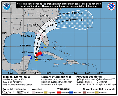
Idalia is currently a strong tropical storm with wind speeds of 65 mph (55 kt).
The storm is predicted to under go rapid intensification over the next 24 to 48 hours as it enters the very warm gulf waters.
Peak sustained winds is predicted to be 115 mph (100 kt).
This will be a Category 3 hurricane on the Saffir-Simpson scale.
The current predicted track has the storm slowly moving North with it picking up speed then shifting a bit Eastward.
GEFS and ECMWF models show fairly strong agreement.
The track has narrowed and shifted slightly to the East with landfall on Wednesday somewhere between Apalachee Bay and Tampa Bay.
In addition to the winds, storm surge and localized flash flooding is expected.
FORECAST POSITIONS AND MAX WINDS
INIT  28/0900Z 20.1N  85.2W   55 KT  65 MPH
 12H  28/1800Z 21.1N  85.1W   65 KT  75 MPH
 24H  29/0600Z 22.6N  85.1W   70 KT  80 MPH
 36H  29/1800Z 24.8N  84.8W   85 KT 100 MPH
 48H  30/0600Z 27.7N  84.0W  100 KT 115 MPH
 60H  30/1800Z 30.7N  82.1W   65 KT  75 MPH...INLAND
 72H  31/0600Z 32.8N  79.0W   55 KT  65 MPH...OVER WATER
 96H  01/0600Z 34.5N  72.0W   50 KT  60 MPH
120H  02/0600Z 34.5N  67.0W   50 KT  60 MPH
The National Hurricane Center has the latest track along with wind speeds and other graphics.
Note: Right now Lemmy is being weird and isn't letting me upload images.


